Home / Bṛhat Saṁhitā / Chapter 54
Exploration of Water Springs (Dakārgala)
Like the architecture chapter, Dakārgala is treated by Varāhamihira as a complete, independent science — the art of locating subterranean water. The word unpacks as daka (short for udaka, "water")
- argala ("a bar or bolt"): the science of water locked up in the bowels of the earth, i.e. the
method for tapping underground water (BS 54, p544). [modern: Bhat 1981] The chapter has two halves with two
named authorities: Varāhamihira says he has summarized Sage Sarasvata's teaching in the Āryā metre
(verses 1–98) and then Sage Manu's in the Vṛtta metres (verses 99 onward); Bhaṭṭotpala's commentary
is the only surviving channel for both, since no work of Manu on Dakārgala has been recovered, which is
why the commentary carries unusual weight here (BS 54, p544). [modern: Bhat 1981] The verses themselves are
[classical]; Utpala's glosses are[traditional]; Bhat's text-critical and identification notes are[modern: Bhat 1981].
A practical note on the units, since the whole chapter runs on them: a Puruṣa is the height of a man with arms raised — 120 digits = 5 cubits — and depths are mostly given in Puruṣas (so "2½ cubits" is half a Puruṣa, "5 cubits" is one Puruṣa), while lateral distances from the tree are given in cubits (BS 54.5, p545). [modern: Bhat 1981] This split — depth in Puruṣas, sideways distance in cubits — becomes a recurring interpretive crux late in the chapter.
The science and the water-veins
Varāhamihira opens by declaring that he will expound "Water-Divination," which "leads to religious merit and fame, as it helps men to ascertain the source of water." The governing analogy is the body: "Just as there are veins in the human body, even so do they exist, some higher up, others lower down, in the earth." Rain-water, though uniform in colour and taste as it falls, takes on various colours and tastes from the nature of the soil it passes through, so water must always be judged in relation to its surroundings (BS 54.1–4, p544).
The eight directional water-veins (siras) are named after the deities of the eight quarters, beginning in the east: Indra (E), Agni/Fire (SE), Yama (S), Nirṛti/the demon (SW), Varuṇa/Lord of water (W), Vāyu/Wind (NW), Soma/the Moon (N), Śiva/Īśāna (NE). A ninth, the Great Vein (Mahāsiras), lies in the centre of these. From these nine, hundreds of branch-veins run off, each with its own name (BS 54.5–6, p545). The verdict on quality by direction: a vein rising up from the nether-world is auspicious; veins in the four cardinal points are auspicious; veins in the four intermediate (corner) quarters are inauspicious (BS 54.6, p545).
Trees as indicators — jungle and watery tracts
The bulk of the chapter is a long, precise catalogue: a tree (often combined with the presence and direction of an ant-hill) tells you that water lies at a stated depth, a stated lateral distance, and in a stated direction from the tree, with a predictable sequence of strata — creatures, clays, and stones — encountered on the way down. The reader is meant to read the tree, the ant-hill's bearing, and then dig. Bhat notes the depths in this jungle/watery section range from a minimum of 7½ cubits to a maximum of 37½ cubits (BS 54, p561). [modern: Bhat 1981] Read in the book's order:
- Rotang (cane) in a waterless tract → a westerly vein, 3 cubits west of the tree. Strata: at 2½ cubits a pale-white frog, then yellow clay, then a hard stone (breakable only with much heat), then water (BS 54.5, p545).
- Jambu (rose-apple) in a waterless place → an easterly vein, depth 10 cubits, 3 cubits north of the tree. Strata: earth smelling of iron at 5 cubits, then pale-white clay, then a frog (BS 54.6, p546).
- Ant-hill east of a Jambu → sweet water, depth 10 cubits, 3 cubits south. Strata: at 2½ cubits fish, then a dove-coloured stone, then blue clay, then inexhaustible water lasting long (BS 54.7, p546).
- Indian fig (with or without an ant-hill) in a waterless place → a vein of good water, depth 12½ cubits, 3 cubits west. Strata: at 5 cubits a white snake, then a stone black as collyrium, then the vein (BS 54.8, p546).
- Ant-hill north of an Arjuna → depth 17½ cubits, 3 cubits west. Strata: at 2½ cubits a white alligator; at 5 cubits grey clay; then dark, yellow, white, and sandy earth; then abundant water (BS 54.9, p547).
- Nirguṇḍī overgrown with (or near) an ant-hill → sweet, never-failing water, depth 11½ cubits, 3 cubits south. Strata: red fish at 2½ cubits, red-brown clay, pale-white clay, sand with gravel, then water (BS 54.10, p547).
- Ant-hill east of a jujube → water 3 cubits west, depth 15 cubits; a white lizard at 2½ cubits (BS 54.11, p547).
- Jujube with a Palāśa (in a waterless place) → depth 16½ cubits, 3 cubits west; a non-poisonous snake at 5 cubits (BS 54, p547–548).
- Bilva joined with an Indian fig → depth 15 cubits, 3 cubits south; a black frog at 2½ cubits (BS 54.12, p548).
- Ant-hill near an opposite-leaved fig (Phalgu) → a westerly vein beneath, depth 10½ cubits. Strata: pale-yellow clay and white stone, and a white rat at 2½ cubits. (Utpala places the vein directly under the ant-hill; Bhat keeps the standard rule — 3 cubits west of the ant-hill (BS 54.13, p548). [modern: Bhat 1981])
- Kampillaka in a waterless place → a southerly vein, 3 cubits east, depth 16½ cubits. Strata: blue clay, dove-coloured clay, and at one cubit further a fish smelling of goat, then a little brackish water (BS 54.14, p548–549).
- Śoṇaka in a waterless tract → the vein named Kumuda, depth 15 cubits, 2 cubits north-west (BS 54, p549).
- Ant-hill south of a Beleric Myrobalan → a vein 2 cubits east, depth 7½ cubits (the shallowest in this section) (BS 54, p549).
- Ant-hill west of the same (Beleric Myrobalan) → a westerly vein, 1 cubit north, depth 22½ cubits; at 5 cubits a white reptile (or scorpion), then a crimson stone, then the vein — but this vein dries up after three years (BS 54, p549).
- Ant-hill (darkened by holy grass) north-east of a mountain-ebony → inexhaustible water, depth 22½ cubits, located between the tree and the ant-hill. Strata: a lotus-calyx-coloured snake at 5 cubits, red earth below, and lower a corundum (ruby) stone (BS 54, p550).
- Echites covered by ant-hills → water at depth 25 cubits, 1 cubit north. Strata: a green frog at 2½ cubits, earth like yellow orpiment, a stone dark as cloud, then a northerly vein of good water (BS 54, p550).
- A frog seen at the foot of any tree → water at depth 22½ cubits, 1 cubit north. Strata: a mongoose at 5 cubits, blue clay, yellow, then white clay, then a frog-shaped stone, then water (BS 54, p551).
- Ant-hill south of a Gray Bonduc → a vein at depth 17½ cubits, 2 cubits south. Strata: a small tortoise at 2½ cubits; first an easterly vein, then a northerly vein of sweet water; a green stone below, then water (BS 54, p551).
- Ant-hill north of a Bassia → depth 37½ cubits (the deepest here), 5 cubits west. Strata: a big snake at 5 cubits, tawny clay, a horse-gram-coloured stone, then an easterly vein of always-foamy water (BS 54, p551).
- Glossy ant-hill (with holy + dūrvā grass) south of a Tilaka → depth 25 cubits, 5 cubits west; the vein is easterly (BS 54, p552).
- Ant-hill west of a Kadamba (Nauclea orientalis) → a northerly vein of inexhaustible water smelling of iron, depth 25 cubits, 3 cubits south. Strata: a golden frog at 5 cubits, then yellow clay (BS 54, p552).
- Palm or coconut covered with ant-hills → a southerly vein, depth 20 cubits, 6 cubits west (BS 54.20, p552).
- Ant-hill south of a wood-apple → depth 25 cubits, 7 cubits north. Strata: a variegated snake at 6 cubits, black clay, a hard stone, white clay, then a westerly vein and next a northerly one (BS 54.21, p552–553).
- Jujube or ant-hill north of an Aśmantaka → depth 17½ cubits, 6 cubits north of the Aśmantaka. Strata: in the first 5 cubits a tortoise, purple stone, clay-with-sand, then a southerly vein and a north-easterly one (BS 54, p553).
- Ant-hill north of a Dāru-Haldī (turmeric-tree) → water 28½ cubits down, 3 cubits east. Strata: a blue snake to 5 cubits, yellow clay, an emerald-like stone, black earth, then a westerly vein and a southerly one (BS 54, p553).
The section closes with herb and ground indicators that do not need a tree: a watery look to the ground, or soft Vīraṇa grass or Dūrvā, signals water at just 5 cubits; a brinjal-like plant, Trivṛt (white Teori), Danti, Sūkarapadī, Lakṣmaṇā, or Navamālikā (double jasmine) creeper → water at 15 cubits, 2 cubits south of the herbs (BS 54.45, p553).
General tree-signs (water present vs. absent)
Across all tracts, the look of a tree betrays the ground: glossy trees with long overhanging branches, or trees either very short or very spreading, have water nearby; hollow trees with pale leaves that are dry do not (BS 54.49, p554). A roster of trees, if very glossy and covered with ant-hills, all give water at 22½ cubits, 3 cubits north: Tilaka, Āmrātaka (Spondias), Varuṇa (Tapia), Bhallātaka (marking-nut), Bilva, Tinduka (ebony), Aṅkola (walnut), Piṇḍāra, Śirīṣa, Añjana, Paruṣaka, Vañjula (Bayas), and Atibala (BS 54, p554).
Other tells: a grassy patch in a grassless field, or a bare patch in a grassy one, marks a vein or buried treasure (the commentary adds the depth should be read as in the prior verse, 4½ Puruṣas) (BS 54, p554). [traditional] A thorny tree among non-thorny ones (or vice versa) → treasure or water at 16½ cubits, 3 cubits west (BS 54, p555). Ground that emits a loud, pleasant sound when struck by the feet → a northerly vein at 17½ cubits at that spot (BS 54, p555). A single branch hanging low or colourless → water at 15 cubits directly under the branch (BS 54, p555). A tree whose fruits and flowers look unnatural (resembling another species') → a vein 20 cubits below, 3 cubits east (stone below, yellow clay) (BS 54, p555). A Kaṇṭakārī (prickly nightshade) without thorns but with white flowers → water beneath at 17½ cubits (BS 54, p555). A double-topped date tree in a waterless area → water 15 cubits down, 2 cubits west (BS 54, p555). A Karṇikāra or Palāśa bearing white flowers (instead of its normal red) → water 2 cubits south, depth 10 cubits (BS 54, p556). Steam or smoke rising from the earth → abundant water at 10 cubits (BS 54.60, p556). A field where grown crops perish, or the vegetation is very glossy and exceedingly white → an abundant vein on the spot at 10 cubits (BS 54, p556). With this the jungle/watery exposition ends and the desert section begins (BS 54, p556). [modern: Bhat 1981]
Trees as indicators — desert tracts
In deserts the veins "run below the earth's surface in the form of a camel's neck (syphons)" — crooked, long, and thin — so desert water is very deep and slender (BS 54, p556). [classical] The depths here are far greater (Bhat: maximum 375 cubits, minimum 25 cubits) (BS 54, p561). [modern: Bhat 1981] In the book's order:
- Ant-hill north-east of a Pīlu → a northerly vein, 4½ cubits west, depth 25 cubits. Strata: in the first Puruṣa (5 cubits) a frog, brown clay, green clay, a stone, then water in plenty (BS 54, p556–557).
- Ant-hill east of the Pīlu → water 4 cubits south, depth 35 cubits; in the first Puruṣa a black-and-white snake one cubit long; to its south a vein with plenty of brackish water (BS 54, p557).
- Ant-hill north of a Karīra (Garil) → sweet water, depth 50 cubits, 4½ cubits south; a yellow frog at 5 cubits (BS 54, p557).
- Ant-hill west of a Rohītaka → a westerly vein of brackish water, depth 60 cubits, 3 cubits south (BS 54, p558).
- Ant-hill east of an Indra-tree (Kahua) → a vein 1 cubit west, depth 70 cubits; a brown alligator at 6 cubits (BS 54, p558).
- Ant-hill north of a Suvarṇaka (Cassia fistula) → brackish water, depth 75 cubits, 2 cubits south. Strata: a mongoose at 2½ cubits, a copper-coloured stone, red earth, then a southerly vein (BS 54.70, p558).
- Jujube joined with a Rohita (± ant-hill) → sweet water, depth 80 cubits, 3 cubits west; a southerly vein first, then a northerly one; strata: paste-like stone, white clay, a scorpion at 2½ cubits (BS 54, p558).
- Jujube joined with a Karīra → a north-easterly vein of copious water, depth 90 cubits, 3 cubits west (BS 54, p559).
- Jujube combined with a Pīlu → inexhaustible brackish water, depth 100 cubits, 3 cubits east (BS 54, p559).
- Kakubha (Indradru?) with a Karīra, or Kakubha with Bilva → water 125 cubits down, 2 cubits west (BS 54, p559).
- Pale-white Dūrvā or holy grass on top of an ant-hill → sink a well in its middle; water at 105 cubits (BS 54, p559).
- Dūrvā on an ant-hill amid Kadamba trees → water at 125 cubits, 2 cubits south of the ant-hill (BS 54, p559).
- A Rohītaka with three other different trees, set in the centre of three ant-hills forming a triangle → water 200 cubits below, 4 cubits 16 digits north of the centre; stone at the bottom, then the vein (BS 54, p560).
- Ant-hill north of a knotty Śamī (Saen) → depth 250 cubits, 5 cubits west (BS 54, p560).
- Five ant-hills together with the central one white → a vein under the central one at 275 cubits (BS 54, p560).
- Śamī joined with a Palāśa → water 300 cubits below, 5 cubits west; at 2½ cubits a snake first, then yellow clay with gravel (BS 54, p560).
- A white Rohītaka surrounded by an ant-hill → water 350 cubits down, 1 cubit east (BS 54, p560).
- A white Śamī full of thorns → water 375 cubits down (the deepest), 1 cubit south; a snake at 2½ cubits (BS 54, p561).
Reconciling the tracts — jaṅgala, anūpa, and maru
Varāhamihira then gives the rule for mixed terrain. The signs above belong to particular land-types, and you must predict from the type of land, not merely the sign: do not read desert symptoms in a semi-desert (jaṅgala / sero-desert) area as if it were desert. If the waterless-tract signs (Jambu, Vetasa, etc.) appear in a true desert, double the stated depth (BS 54, p561). The principle, as Bhat frames it: signs of one tract found in another are adjusted — jaṅgala depths doubled in desert, desert depths halved in watery (anūpa) land (BS 54, p561). [modern: Bhat 1981]
Worked illustrations of the principle follow: a long list of creepers/herbs (Jambu, Trivṛt, Maurvī, Śiśumārī, Sārivā, Śivā, Śyāmā, Vārāhī, Jyotiṣmatī, Garuḍavega, Sūkarikā, Māṣaparṇī, Vyāghrapāda) growing on an ant-hill → water 15 cubits below, 3 cubits north of the ant-hill — but these measures hold only in water-rich land; in a semi-desert the depth becomes 25 cubits, and in a desert 35 cubits (BS 54.88, p562). A uniform, grass/tree/ant-hill-free patch that nonetheless shows some unusual feature → water at 25 cubits (BS 54.90, p562). Soft (not dry), low, sandy, or sound-emitting earth → water at 22½ or 25 cubits (BS 54, p562).
More of the same: very glossy trees → abundant water 20 cubits below, to their south (likewise a tree showing uncommon features amid a thicket — water 20 cubits to its south) (BS 54, p563). Earth that sinks underfoot, or where insects swarm with no nest, in semi-desert or watery land → water at 7½ cubits (BS 54, p563). An isolated cold spot in warm ground (or vice versa) → water at 17½ cubits; and where a rainbow, ant-hill, or fish appears in semi-desert/watery land → water at that same depth, 4 cubits away (BS 54, p563). In a row of ant-hills, one taller than the rest → a vein 4 cubits beneath it; likewise where grown vegetation withers or fails to sprout — for semi-desert and watery tracts only (BS 54, p563).
Open question (the chapter's own crux, p563–564): depth is normally given in Puruṣas and lateral distance in cubits, but Utpala reads several verses (e.g. the "4 cubits" of the taller ant-hill, and the banyan + Butea + fig cluster giving "3 cubits") as depths rather than distances. Bhaṭṭotpala and Sage Sarasvata's ablative phrasing leave it genuinely ambiguous whether the figure is a vertical depth or a horizontal reach; Bhat's earlier edition took it as horizontal. The text does not resolve which reading is right. [modern: Bhat 1981]
A banyan + Butea Frondosa + glomerous fig, or banyan + holy fig together → water beneath at 3 cubits depth, vein flowing north (alternatively: 3 cubits away, depth 15 or 17½ cubits — the same depth/distance ambiguity) (BS 54, p564).
Wells by quarter of a town
Two verses give the effect of sinking a well in each quarter of a village or town: a well to the south-east brings constant fear and danger from fire; to the south-west, infant mortality; to the north-west, danger to women. Wells in any other quarter are auspicious. Utpala notes this applies to wells in houses too (BS 54.97, p564). [traditional]
Sage Manu's section (the Vṛtta metres) — soils and stones
With verse 99 Varāhamihira closes the Sarasvata (Āryā) exposition — "studied from the work of Sage Sarasvata" — and turns to Sage Manu's teaching in the Vṛtta metres (BS 54.98–99, p565). This second half shifts from trees to the colour, texture, and sound of the ground and its stones.
Vegetation and herbs (water at 15 cubits): glossy, densely-leaved trees/bushes/creepers (or leaves without holes); or land-lotus, Gokṣura, Ṣaḍaṅga, Uśīra, Kula, Guṇḍra, Kāśa, Nalikā, or Nala grass; or date, Jambu, Arjuna, Vetasa, or milky trees/shrubs/creepers; or mushrooms, Hastikarṇa, Nāgakeśara, Śatapatra, Kadamba, Karoja, Sinduvāra, Vibhītaka, or Madayantikā; also at a mountain's foot if that mountain is surmounted by another — and the commentary specifies the water lies at the foot of the upper mountain (BS 54.101, p565). [traditional]
Soil colour → water and its taste: plenty of sweet water where there is Muñja grass, reeds, and sacrificial grass, and the earth is blue with pebbles, or black or red (BS 54.103, p566). The taste-by-soil rule: copper-coloured earth with gravel → astringent water; red-brown earth → brackish; pale-white earth → salt; blue earth → sweet (BS 54.104, p566) — the verse the chapter's own opening (54.4) points forward to.
Signs of waterlessness, and water far off: Tāka, Aśvakarṇa, Arjuna, Bilva, Sarja, Śrīparṇī, Ariṣṭa, Dhava, Śiṁśapā, and other trees that are coarse with holey leaves, indicate water far away (BS 54.105, p566). Land coloured like the Sun, fire, ashes, a camel, or a donkey is waterless; but a Karīra exuding milk with red sprouts over red earth → water under stones (BS 54.106, p566).
Reading the rocks: a rock like beryl, green-gram, cloud, dark gem, ripe fig, bee, collyrium, or brown → abundant water nearby (BS 54.107, p567). A rock like a pigeon, honey, ghee, silk, or the Soma creeper → inexhaustible water soon (BS 54, p567). A rock with red or variegated spots, or pale-white, or the colour of ashes/camel/donkey/Sun/fire/bee/the Aṅguṣṭhikā flower → gives no water (BS 54, p567). Stones with the lustre of moonlight, crystal, pearl, gold, sapphire, vermilion, collyrium, the rising Sun's rays, or yellow orpiment are auspicious (BS 54, p567). These auspicious stones must not be broken — they are tenanted by Yakṣas and Nāgas; a kingdom containing them never suffers drought (BS 54, p567).
Breaking a stubborn rock
When a stone over the vein will not break by hammering, Manu gives heat-and-quench methods (BS 54, p568):
- Burn a fire on it with Palāśa and Tinduka logs until it glows red, then sprinkle it with lime water; it breaks easily (BS 54, p568).
- Boil the ashes of the Mokṣaka tree in water with reed-ashes and sprinkle the heated rock seven times with the decoction (BS 54, p568).
- Keep buttermilk, sour gruel, and liquor with horse-gram and jujube fruit for seven nights, then pour it on the heated rock — Bhat argues the pouring (and re-heating) should likewise be repeated seven times, from the verse's plural (BS 54, p568). [modern: Bhat 1981]
- Burn to ash the leaves and bark of Neem, sesamum stalks, Apāmārga, Tinduka, and Amṛtā creeper, dissolve in cow's urine, and pour six times on the successively-heated stone (BS 54, p569).
Open question (p569): verses 116–117 simply repeat 53.25–26 (on the sword/instrument-omens). Neither Bhat nor Utpala can explain their relevance to stone-breaking; Bhat guesses the unguents and ashes mentioned there are meant to be applied to the heated stone, or to make the hammer more effective — unresolved. [modern: Bhat 1981]
Ponds, wells, purification, and the right asterism
The chapter ends with construction and finishing (BS 54, p569–571):
- Pond orientation: a rectangular tank with its long banks east–west holds water long; one with long banks north–south does not, being eroded by wind-driven waves. If the land forces a north–south tank, reinforce its walls against the water with strong timber, stone, or burnt brick, and harden the bed by having elephants and horses trample it (BS 54.118, p569–570).
- Shade trees for the banks: Arjuna, banyan, mango, pīpal, Nauclea orientalis, Hijjal, Eugenia, Bayas (or Bent), Nīpa (Dhūlikadamba?), crimson globe-amaranth, Tāla, Aśoka, Bassia, and Bakula (BS 54, p570).
- The outlet is made on one side with a stone sluice and a solid aperture-less panel set in a frame and fastened to the earth with mud (BS 54, p570).
- Water purification: drop into the well a mixture of antimony, powdered Bhadramusta bulbs, andropogon, Rājakośātaka, and myrobalan combined with Kataka (clearing-nut) seeds — six ingredients — and even muddy, bitter, saltish, ill-tasting, foul-smelling water becomes clear, sweet, fragrant, and wholesome (BS 54, p570–571).
- Asterisms for sinking a well: the beneficial nakṣatras are Rohiṇī, Puṣya, Maghā, the three Uttarās (Uttaraphalgunī, Uttarāṣāḍhā, Uttarabhādrapadā), Hasta, Anurādhā, Dhaniṣṭhā, and Śatabhiṣaj (BS 54.115, p571).
- The rite: first worship Varuṇa with oblations, then plant a peg of banyan or Vetasa wood at the spot of the vein, having honoured it with flowers, perfumes, and incense (BS 54, p571).
Varāhamihira signs off by pairing this chapter with the earlier one on celestial water: he had already treated atmospheric (cloud-born) water, judged after the full Moon of Jyeṣṭha (ch. 23, on the authority of Baladeva and others), and has now expounded the subterranean method "by the grace of the Sages" Sarasvata and Manu (BS 54, p571). The text appends a pointer — "[Note: See Chart of Water-Veins and Indicators]" — to a summary chart. That chart is not printed within this chapter's own pages, but it is printed: it appears as a thirteen-page tabular plate at the very back of Part 1 (PDF p594–606, bound after the Vajralepa chapter), and it belongs here, with the Dakārgala. [modern: Bhat 1981]
The Chart of Water-Veins and Indicators
The chart is a single continuous table running across thirteen book-pages, in effect the whole of this chapter's water-divining science compressed into one lookup table. Its columns are: the direction / type of water-vein found; the depth at which water is found (in cubits, c.); the indicators (the surface sign — a named tree, anthill, grass, rock, soil-colour, or animal); the distance and direction to dig from that indicator; and what lies underneath (the intervening strata — frogs, snakes, stones, coloured clays — met on the way down). Read a surface sign, dig a stated distance in a stated direction, expect water at a stated depth (BS 54, p594–606).
A few representative rows convey its form: a Vetasa (cane) tree in a waterless tract → water at 7½ cubits, 3 c. to the west, with a pale frog and yellow clay below hard stone; an anthill north of an Arjuna tree → 17½ c.; a Bilva tree joined with an Indian fig → 15 c., 3 c. west; an anthill amid a group of five anthills → water under the central anthill at 27½ c. The chart also keys the quality of water to soil and stone colour: copper-coloured gravelly earth → astringent water; red-brown → brackish; pale-white → salt; bluish earth → sweet; and rock like beryl, green-gram, dark gem, ripe fig, bee, or collyrium signals abundant water nearby (BS 54, p594–606).
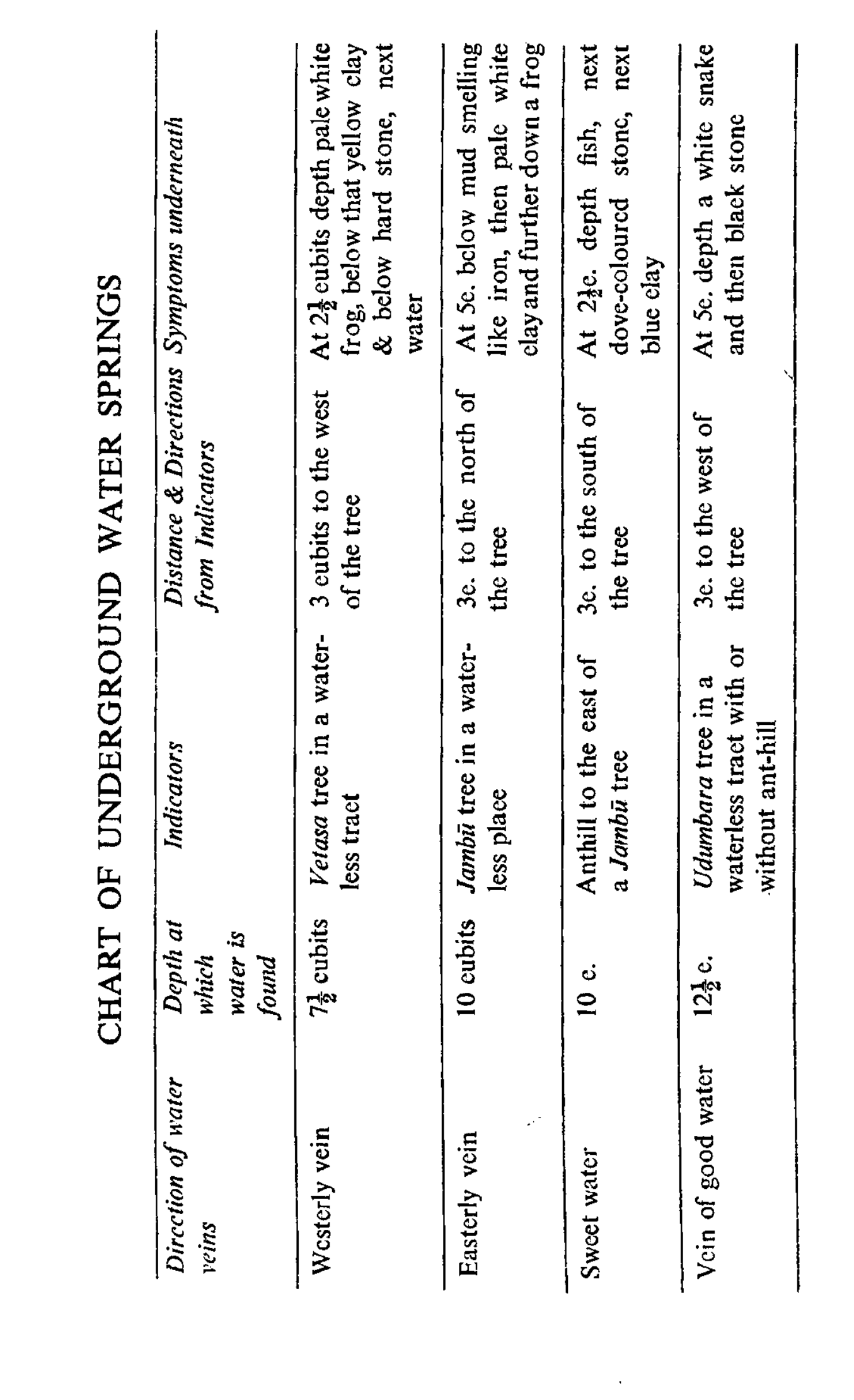 Chart of Water-Veins and Indicators (1/13) — header row and the first water-vein types (p594/printed p549).
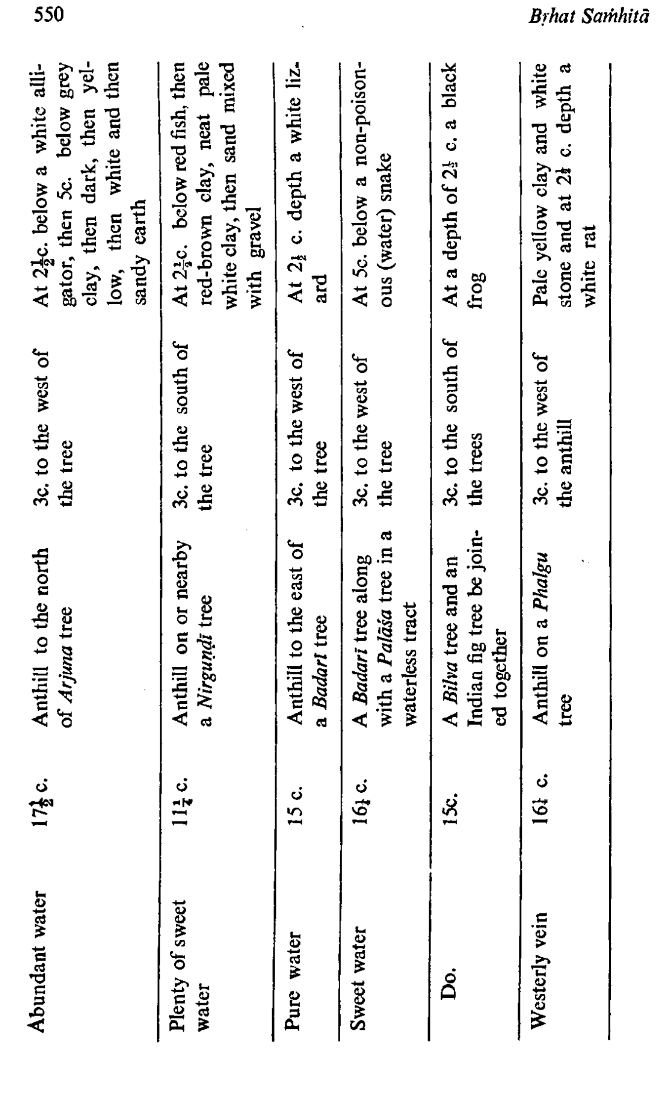 Chart of Water-Veins and Indicators (2/13) — indicators from named trees and anthills (p595/printed p550).
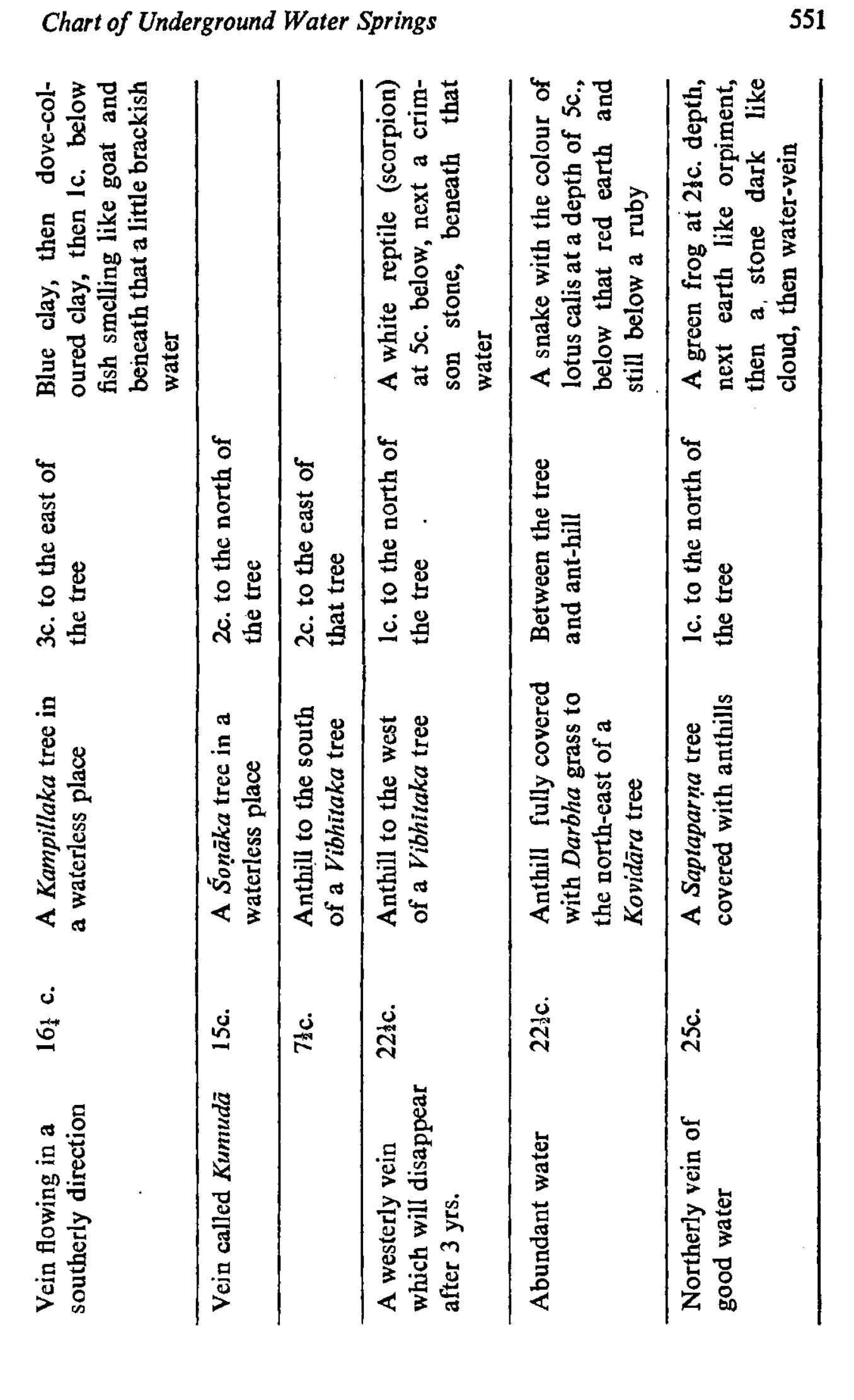 Chart of Water-Veins and Indicators (3/13) — further tree- and anthill-indicators (p596/printed p551).
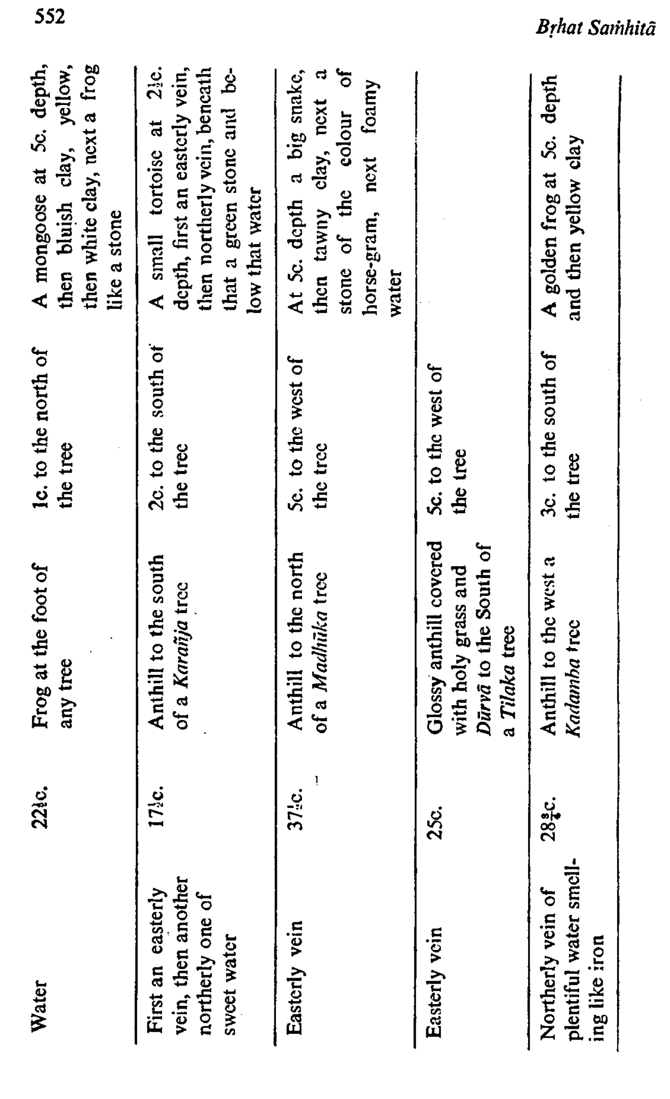 Chart of Water-Veins and Indicators (4/13) — strata (tortoise, stone, frog) encountered while digging (p597/printed p552).
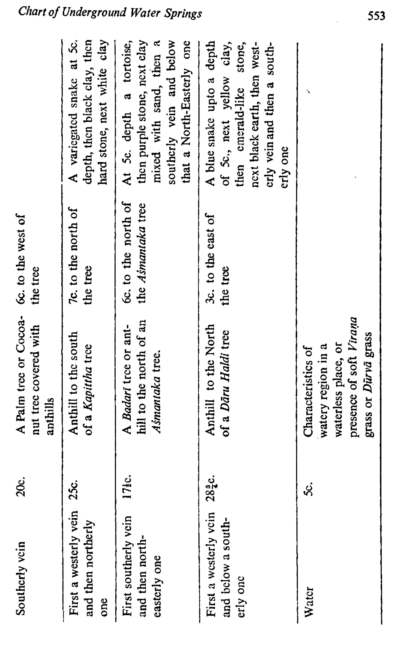 Chart of Water-Veins and Indicators (5/13) — palm/cocoanut and watery-region indicators (p598/printed p553).
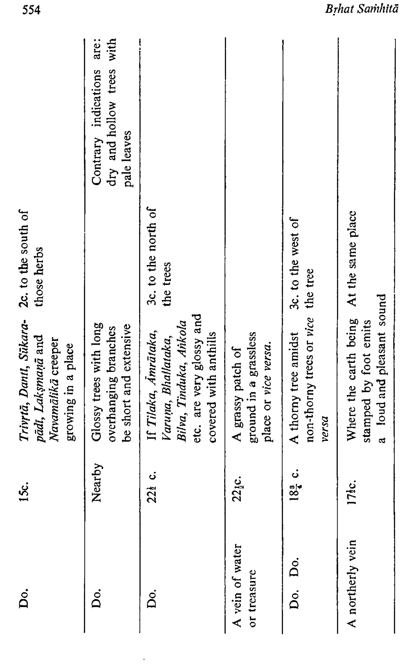 Chart of Water-Veins and Indicators (6/13) — herb/creeper indicators and signs of buried water or treasure (p599/printed p554).
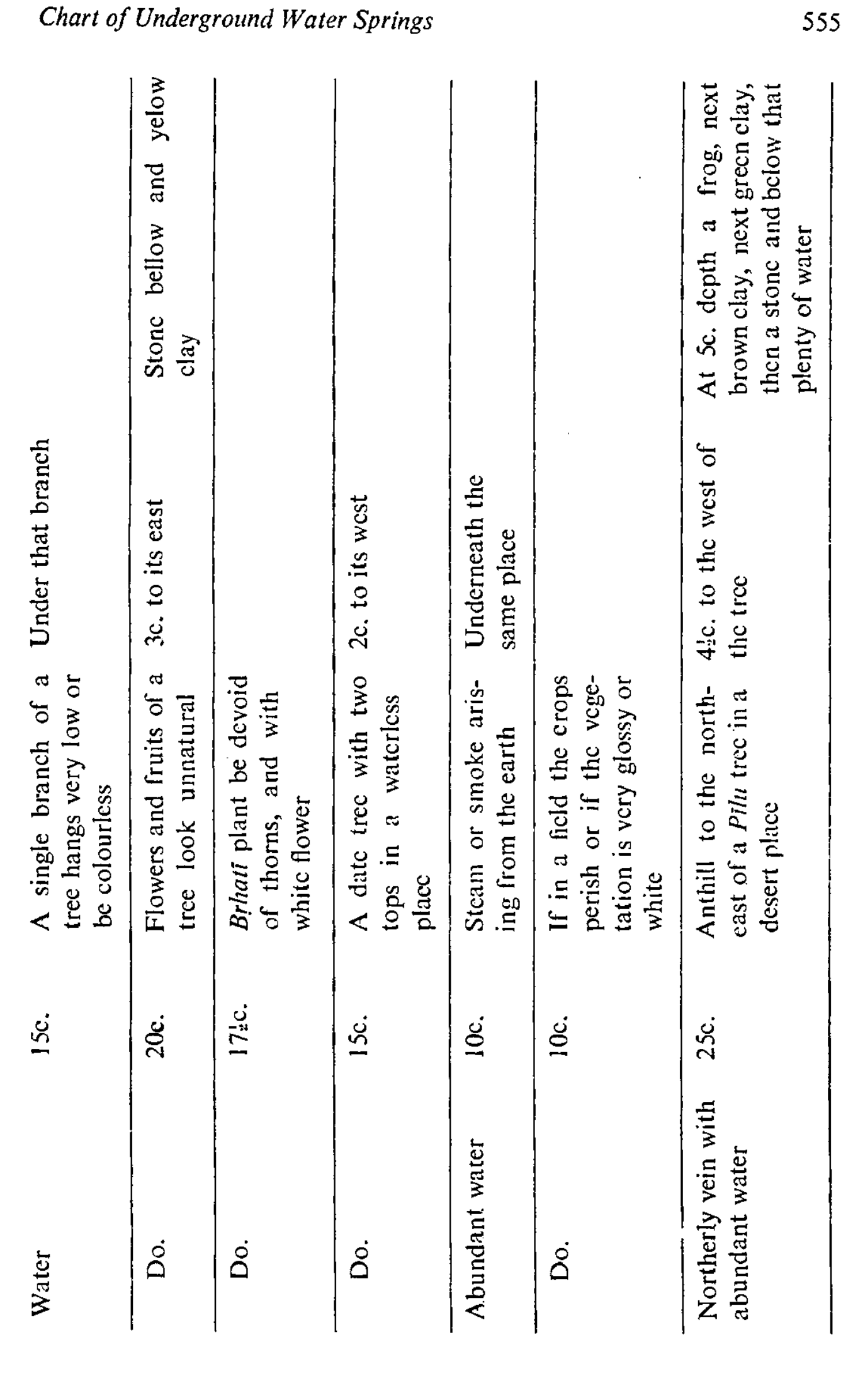 Chart of Water-Veins and Indicators (7/13) — low-branch, thornless and disc-tree omens; water below at stated depths (p600/printed p555).
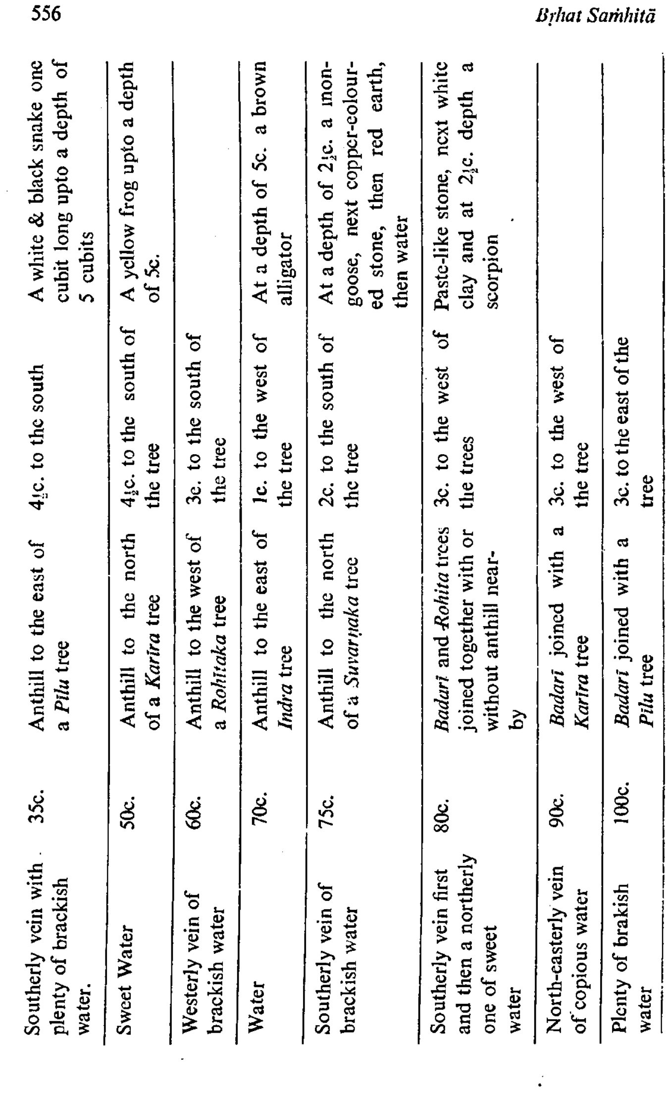 Chart of Water-Veins and Indicators (8/13) — brackish/sweet veins keyed to Pīlu, Karira and Suvarṇaka trees (p601/printed p556).
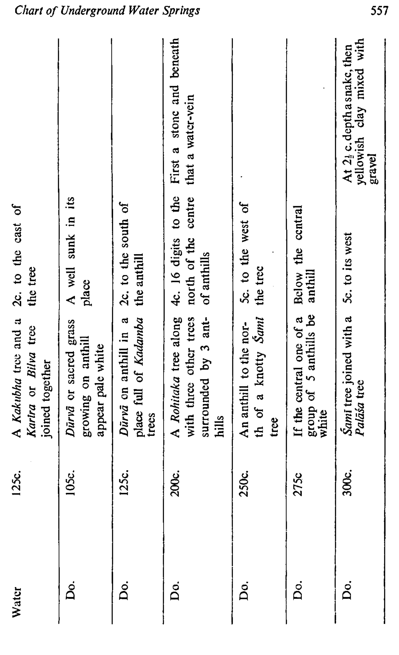 Chart of Water-Veins and Indicators (9/13) — anthill-and-grass indicators with depths to 300 cubits (p602/printed p557).
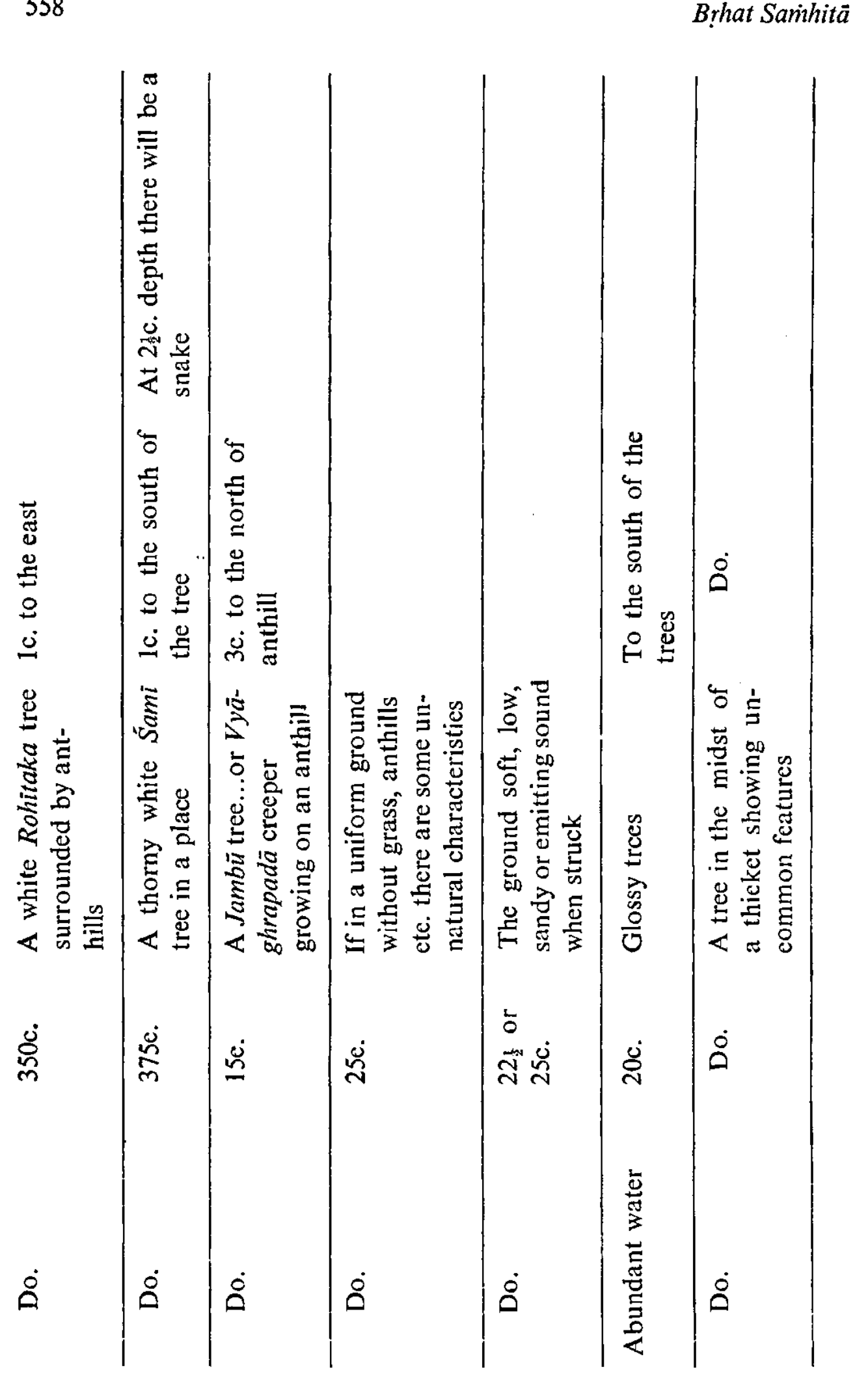 Chart of Water-Veins and Indicators (10/13) — Rohitaka, Śamī and Jambū indicators; abundant water (p603/printed p558).
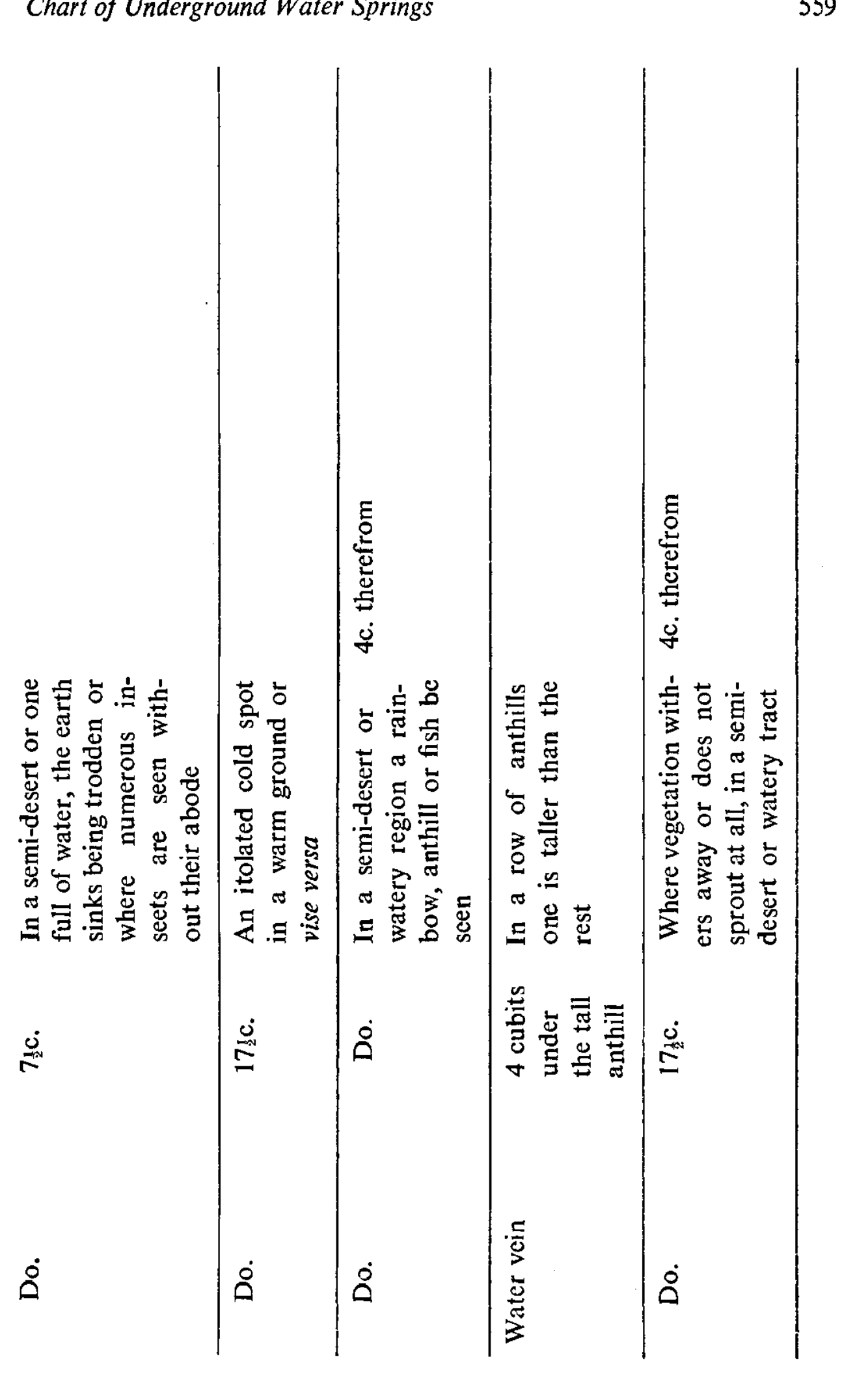 Chart of Water-Veins and Indicators (11/13) — semi-desert and anthill-row omens; water-vein 4 c. below (p604/printed p559).
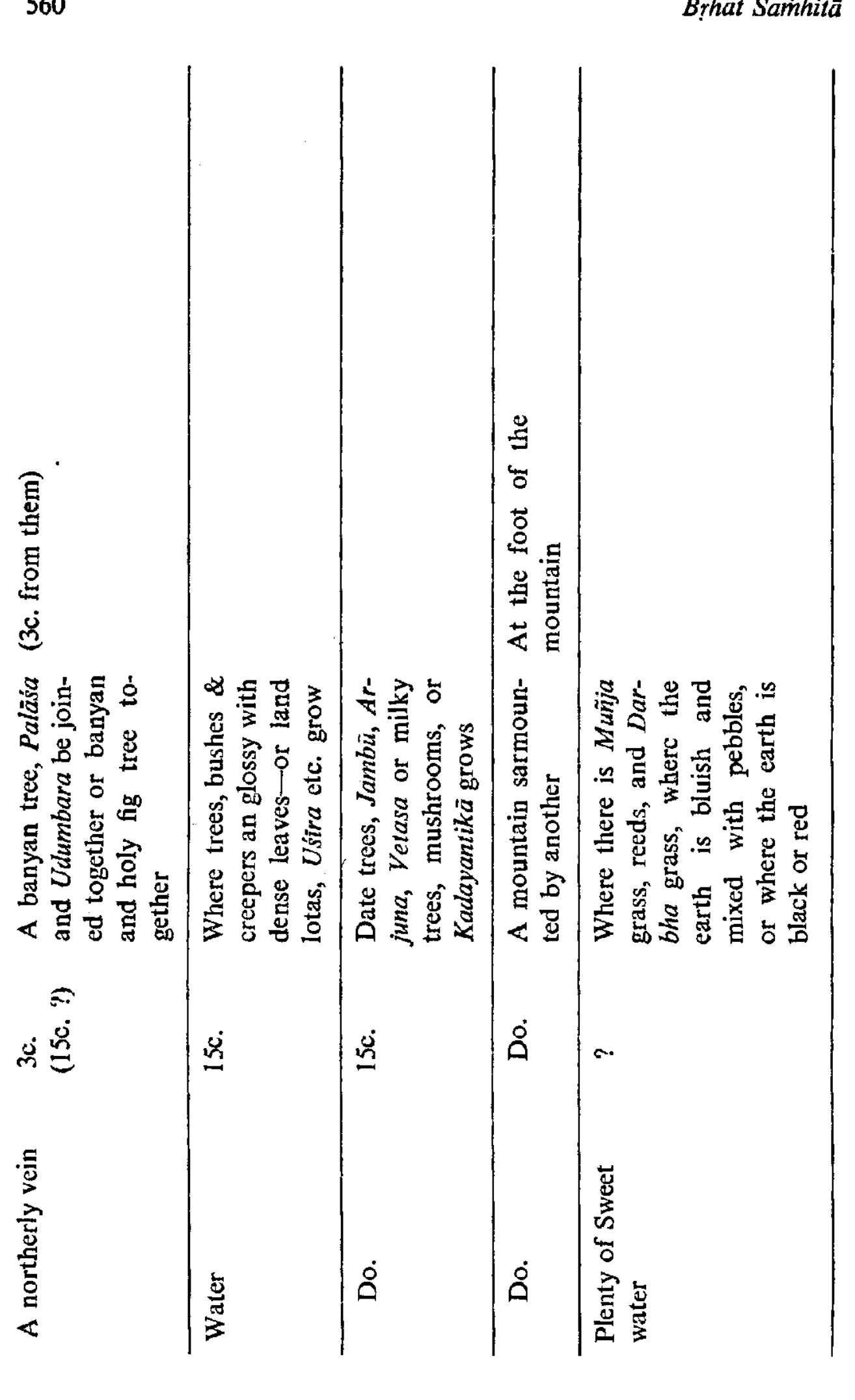 Chart of Water-Veins and Indicators (12/13) — banyan-cluster, milky-tree, mountain and grass indicators (p605/printed p560).
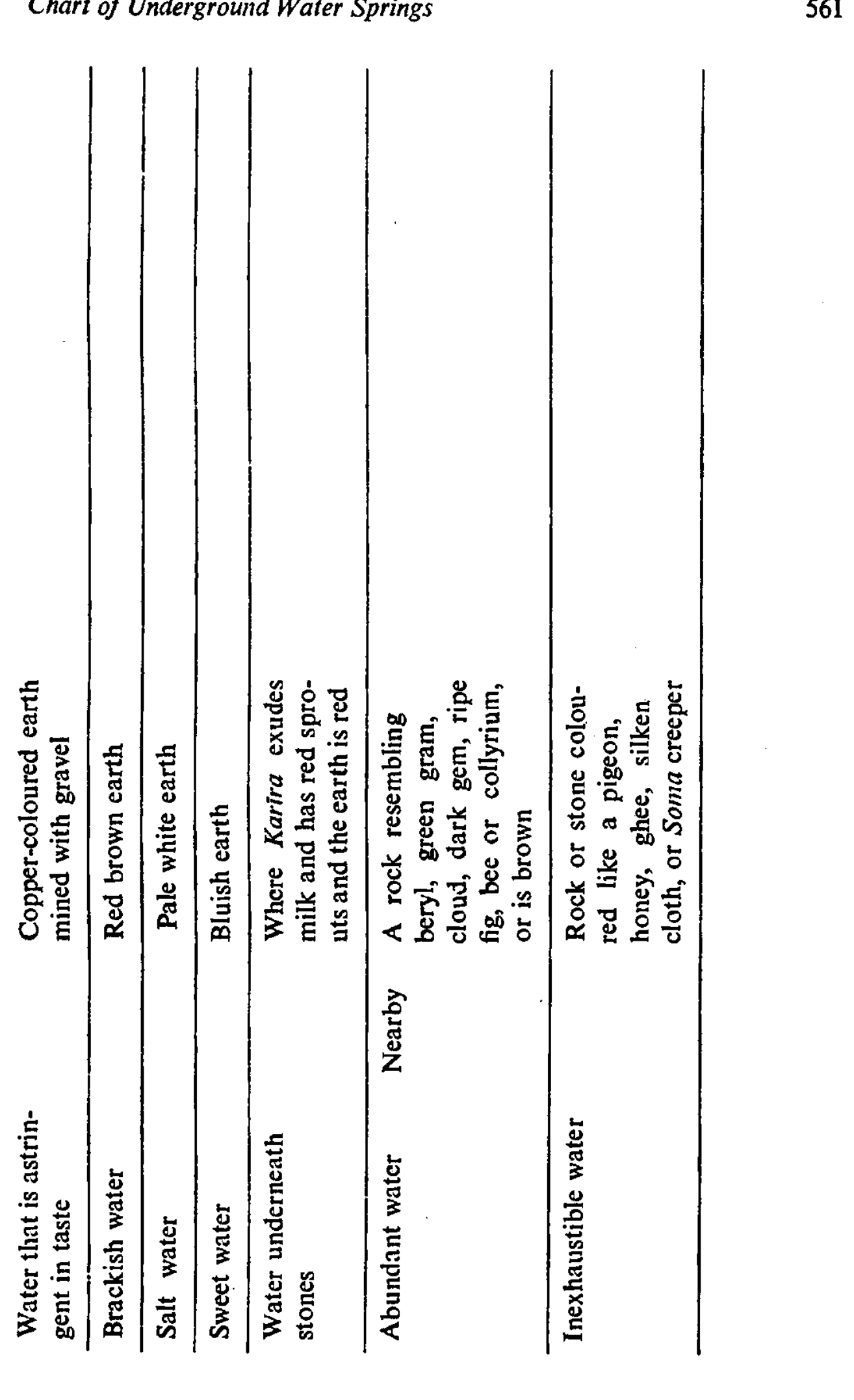 Chart of Water-Veins and Indicators (13/13) — the soil/stone-colour key to water quality (p606/printed p561).